There's a good chance that Tropical Depression 8 could form along a tropical wave in the central Gulf of Mexico over the next few days as it moves west northwest at 10 mph, the National Hurricane Center warned Wednesday afternoon.
If it does form, a tropical storm watch or warning might have to be issued for part of Louisiana's coast Wednesday night or Thursday, according to the Slidell office of the National Weather Service.

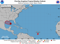
A tropical depression is likely to form within the red hatched area in the Gulf of Mexico over the next few days. Tropical Storm Gonzalo, in the central Atlantic, is expected to gain minimal hurricane strength on Thursday.
"Data from the Air Force Hurricane Hunters and surface observations indicate that an area of low pressure over the central Gulf of Mexico is gradually becoming better defined," said John Cangialosi, a Senior Hurricane Specialist with the National Hurricane Center.
"However, the accompanying shower and thunderstorm activity is still poorly organized. Environmental conditions appear conducive for slow development of this system, and a tropical depression is likely to form during the next day or so as it moves west-northwestward at about 10 mph," he said.
There was an 80% chance of the depression forming by Friday and a 90% chance it will form over the next five days.


Thunderstorm activity was growing in the central Gulf of Mexico on Wednesday afternoon.
An Air Force Reserve Hurricane Hunter flew out to investigate the tropical wave on Wednesday afternoon.
Off we go! ✈️⛈🌪🌊 On our way to fly low level invest into 91L.#ReserveReady #ReadyAF #WC130J @403rdWing @NHC_Atlantic @NOAA_HurrHunter pic.twitter.com/5NKoGL5GJQ
— Hurricane Hunters (@53rdWRS) July 22, 2020
The official forecast suggests the depression could form anywhere within a broad area of the northwest Gulf that skirts the southern Louisiana coast and includes much of the eastern Texas coastline.
The depression is expected to make landfall on the Texas coast on Saturday, according to an afternoon forecast message from the Slidell office of the National Weather Service.

"Main concerns here will be bands of heavy rainfall, and potential for minor coastal flooding," the Weather Service said. Widespread rainfall totals of 1 to 2 inches are expected through Saturday, with much higher totals possible in isolated pockets, especially Thursday afternoon and Friday in areas south of Lake Pontchartrain. The rain bands could be accompanied by winds of as much as 45 mph and a few stronger gusts.
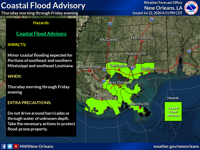
The weather service also issued a coastal flood advisory that will be in effect from 7 a.m. Thursday through 7 p.m. Friday for minor coastal flooding.
Persistent east to southeast winds of 15 to 25 mph through Friday will produce tide levels 1 to 2 feet above normal during high tide cycles on Thursday and Friday, mostly along east and southeast-facing shorelines.
After the depression moves into Texas, expect occasional "impulses" -- tiny pockets of low pressure -- to move into south Louisiana from the northern Gulf early next week, triggering periods of thunderstorms capable of producing heavy rainfall, forecasters said.
"No obvious dry day in the batch. Heaviest rainfall is expected to remain offshore, but will need to continue to monitor," the local forecast message said. The good news is that the rain chances should hold high temperatures below normal.

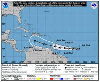
Tropical Storm Gonzalo is forecast to reach hurricane strength on Thursday.
Meanwhile, Tropical Storm Gonzalo was in a slight delay in intensifying as it sped west at 14 mph across the central Atlantic Ocean on Wednesday afternoon. Though it had top winds of 50 mph, forecasters predicted that it would reach Category 1 hurricane strength, 75 mph, by Thursday.
"Satellite imagery suggests that Gonzalo's intensification has paused since the last advisory (at 10 a.m. Wednesday)," said Senior Hurricane Specialist Jack Beven in a 4 p.m. message. "The cyclone continues to show a central dense overcast, and microwave imagery indicates a small convective ring (of thunderstorms) present under the overcast."

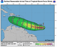
This graphic shows the earliest reasonable time for the arrival of tropical storm-force winds, 39 mph or greater, as Gonzalo moves into the Caribbean Sea.
Both the overlying clouds have become ragged and rain bands seen earlier had dissipated, he said. The storm continues to be on track to move near or over the southern Windward Islands over the weekend, bringing with it high winds and heavy rainfall.
Gonzalo's formation as a tropical storm on Wednesday was another sign of what's expected to be a much busier than usual hurricane season. On average, the seventh named storm doesn't occur until Sept. 16, according to NOAA officials.
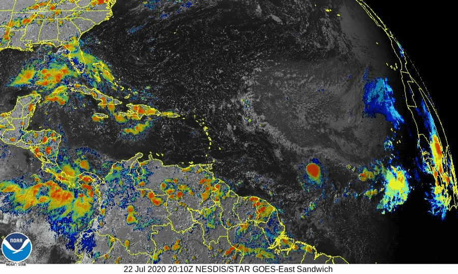
This Wednesday satellite view shows the thunderstorms associated with a tropical wave in the Gulf of Mexico, and the growth of Tropical Storm Gonzalo in the central Atlantic Ocean.
The official forecast calls for Gonzalo to reach hurricane strength, with 75 mph sustained winds, by Thursday afternoon, and increase in strength to about 80 mph on Friday. After that, the forecast calls it to return to tropical storm strength by Saturday evening, and have winds of only 45 mph by 8 a.m. Monday, when it should be in the central Caribbean Sea south of the Dominican Republic.
Beven said forecast models continue to split their forecasts. Some show it entering a light windshear environment over warm sea surface temperatures, which might cause rapid intensification over the next day or two. Other show it simply weakening into an open tropical wave by Sunday, thanks to dry air on its west and southwest sides getting wrapped into the storm's center and an upper level high-pressure system causing its clouds to sink, a process called subsidence.
"8" - Google News
July 23, 2020 at 05:53AM
https://ift.tt/3hwOtVb
Thursday could see Tropical Depression 8 form in Gulf; Tropical Storm Gonzalo become hurricane - NOLA.com
"8" - Google News
https://ift.tt/2z1PBPz
https://ift.tt/3c1rzCJ


No comments:
Post a Comment